|
|
Turnertoys Home Page: "Good Things for Kids" |
|
ED'S OUTDOOR PAGES (fomerly the official website of the Green Mountain Club Montpelier Section) |
Trip Report - July 10,2004
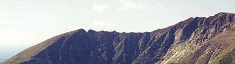
Baxter State Park, Millinocket, Maine: Baxter Peak & the Knife Edge
[Large Page - 55 sec @ 28k - be patient]
| Views on the Knife Edge Katahdin Panorama Aerial View (101 sec @ 28k) | |
|
In July, Paul DeLuca and I climbed Mount Katahdin, Maine's highest peak. Katahdin is located in Baxter State Park, |
|
a 204,733 acre wilderness granted to the State of Maine and declared "forever wild" by benefactor and former governor Percival Baxter. The park has 47 mountain peaks and ridges, 18 of which exceed 3,000 feet. Baxter Peak, near the western end of the Katahdin ridge, is at 5,267 feet the highest point in Maine, and is the northern terminus of the Appalachian Trail. |
|
| Mt. Katahdin is actually a large cirque or amphitheater-shaped ridge, with several named peaks, of which Baxter is the highest. Toward the northeastern end there is Chimney Peak at 4,912 ft and Pamola Peak at 4,997 ft. The portion between Baxter and Chimney Peaks is called the Knife Edge, a narrow ridge with steeply-sloped, occasionally vertical walls on either side. At some points, the trail along this ridge is just a foot or two wide. From Pamola Peak, two ridges slope sharply downhill, east along the Helon Taylor Trail, and north to Chimney Pond along the Dudley Trail. | |
|
The Block Shoppe Trains Woodkins Rattles & tops, Old-Fashion Wood Toys Toy Finder Airplanes Toddler Play Structures |
We ascended via the Abol Trail (2.76 mi), with a long, flat approach and very steep climb once it reaches the mountain itself. The upper part ascends 2000 ft in .7 miles. The trail has a base of sand, rather than the soil we see in Vermont and New Hampshire. This results in weather gradually loosening the rocks on such a steep trail. Hand-holds and foot placements had to be viewed with suspicion, and tested before weight could be applied; many, from pebble to truck-size boulder, were unstable. Abol ends at Thoreau Pond (Henry David Thoreau was one of the first to explore Katahdin, back in the early 1800's), where it connects with Hunt Trail (the final mile or so of the Appalachian Trail), and ascends .8 miles to Baxter Peak.
|
 Looking down Abol Trail |
 Looking up Abol, just below the plateau leading to Thoreau Spring. Paul is only slightly bent forward - the trail really is about a 75 degree slope. |
||
| We stopped for a short lunch at Baxter Summit, skipping the usual summit photos next to the sign, etc. The summit and ridgeline were in a cloud all day, so views were scarce. | ||
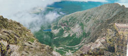
| Although there seemed to be a good chance of rain in the middle of a cloud, we decided to take a chance on a traverse of the Knife Edge. 2/10 miles down the trail, the clouds parted enough to provide this panoramic view of the Chimney Pond Basin, the large valley contained by the Katahdin Cirque. At the upper right corner can be seen the other end of the Knife Edge: |
|
| Chimney Peak, Pamola Peak, and the deep notch between them. View a larger annotated image. | |
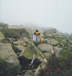
| From Pamola Peak, we descended to Chimney Pond on the
Dudley Trail, a very steep slope consisting mostly of large boulders. The
descent involved a lot of climb-downs, as opposed to walking. Dudley is
only 1.25 miles long, but at this point the descent was starting to feel
like work. Fortunately, all the trails on Katahdin are very well
marked.
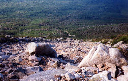
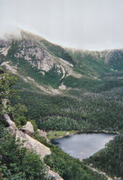
At right is a view from about 500 feet above Chimney Pond. At top of image is the Saddle Ridge which proceeds northward from Baxter and is continuous with Hamlin Peak, Hamlin Ridge, and the Howe Peaks. We hiked back out to the Roaring Brook Campground, approx. 3.3 miles, for a total of 10.5 miles. |
 |
Comments and questions? Email them to ed@turnertoys.com
VISIT THE NEW, OFFICIAL
MONTPELIER SECTION SITE
for the latest trip schedule and much more.
Visit the Green Mountain Club's Official Website: http://www.greenmountainclub.org
 Turnertoys Home Page: "Good Things for
Kids"The Toys we grew up with
Turnertoys Home Page: "Good Things for
Kids"The Toys we grew up with