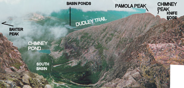
View from the Knife Edge, indicating trails and geographic features
back to Mt Katahdin trip report (July 10, 2004)
Topographic Map
Aerial Image (B&W) 101 sec @ 28k (recommended for broadband users)
Broad-band users: Large High-Res. Photo
(approx 2 min load time @ 28 k)
| View from approximately .2 miles Southeast of Baxter peak into the
South Basin. At right (from right to left) is Chimney Peak, the
Pamola Cleft, Pamola Peak, and the ridge along which Dudley Trail
proceeds downhill to Chimney Pond. The eastern end of the Knife Edge is
just visible at right. The portion of the image at the bottom is
looking almost vertically straight down, just past my shoes. The
"peak" in the background at left is just the lower slope of a
ridge that leads to the northern continuation of the Katahdin ridge, which
includes Hamlin Peak and the Howe Peaks.
This image is a composite of several photos, taken from the same position in 3-D space but aimed at different angles; no single still photo could come so close to reproducing the sense of being in the scene. To get a real feel for the scope of this view, view the full-size image - 150 dpi, 3,362 Kb (3.362 Mb) - recommended for broadband users only (cable or DSL). |
|
back to Mt Katahdin trip report (July 10, 2004)
Topgraphic Map
Broad-band users: Large High-Res. Photo
(approx 2 min load time @ 28 k)